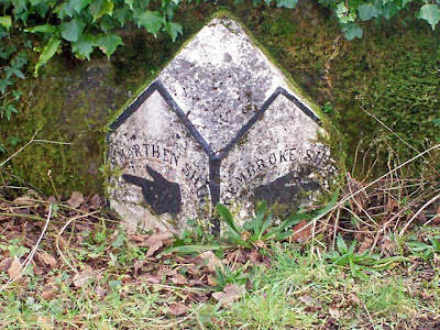
---County Boundary Stone---
We are lucky to have at the eastern end of our village a Grade II Listed Boundary Stone set into Castle Ely Bridge - this is just outsde our village.
---Milestones---
We also have two Milestones - one opposite Myrtle Villaa which is at the eastern end of the village and one on a disused loop of road close to Oakland's House.
---Milestone Makers---
The Milestones are marked 'MOSS & SONS 1838'.
---Turnpike Road---
They are on what was the old main turnpike road from Carmarthen to Hobb's Point.
Later to become the A477 trunk road into South Pembrokeshire.
---Llanteg Toll Gate---
Llanteg Tollgate was run by 'Billy the Gate', William Oriel - who was the village cobbler, tollgate keeper and vilage schoolmaster all rolled into one.
William's wife was an invalid and he would puh her around the village in a basket invalid chair.
Nothing remains of our village tollgate but it appears to have been situated at the S.W. corner of Llanteg Crossroads to the west of Llanteg Garage.
Llanteg - a small village in East Pembrokeshire - has two milestones and a county boundary stone.
County Boundary Stone
Now classed as a grade II listed structure - but under Eglwyscummin parish rramarthenshire -
Description: Boundary stone near Castle Ely Bridge
Grade: II
Date Listed: 1 December 2001
Cadw Building ID: 24493
Date Listed: 1 December 2001
Cadw Building ID: 24493
OS Grid Coordinates: 219043, 210466
Latitude/Longitude: 51.7631, -4.6226
Latitude/Longitude: 51.7631, -4.6226
The County Boundary between Carmarthenshire and Pembrokeshire is the little stream that runs under Castle Ely Bridge. This was the main turnpike road until this loop was bypassed in the 1980s.
The above images were taken in June 2016. It has evidently been weeded around and tidied up but still in need of painting. I have approached Carms County Council but they informed me that it is the Community Council's responsibility. The stone comes under Eglwys Cummin on the listed buildings website so I have passed a message over to them.
Castle Ely Bridge with the boundary stone just visible on the left.
Crunwear Brook flowing under the bridge - it is the county and parish boundary.
County boundary stone - looking in need of a bit of TLC - May 2012.
The Boundary Stone is set into the bridge.
Looking northestwards along Castle Ely Bridge.
2008
2008
2008
2003

The above three pictures show how the Boundary Stone was brought back to life
in 2003 after being completely lost in undergrowth.
Subscribe to:
Comments (Atom)


